The East and South East

The region that stretches from the eastern part of the Ring Road (Route 1) towards the southeast, encompassing areas from Höfn í Hornafirði to the edge of the southern coast.
It is characterized by its dramatic interplay of land and ice with its vast glaciers, waterfalls, and enchanting coastline. The region includes both highland areas and coastal plains.

Home » Destinations » Europe » Iceland » EastandSouthEast

Explore The East and South East

With its imposing glaciers, mighty volcanoes, waterfalls, and enchanting coastline, Southeast Iceland is a popular part of the Icelandic road trip circuit with visitors all year around. Expect crowds in summer months and slower times crossing one-way bridges. The shoulder seasons can provide a more solitary experience with fewer visitors.
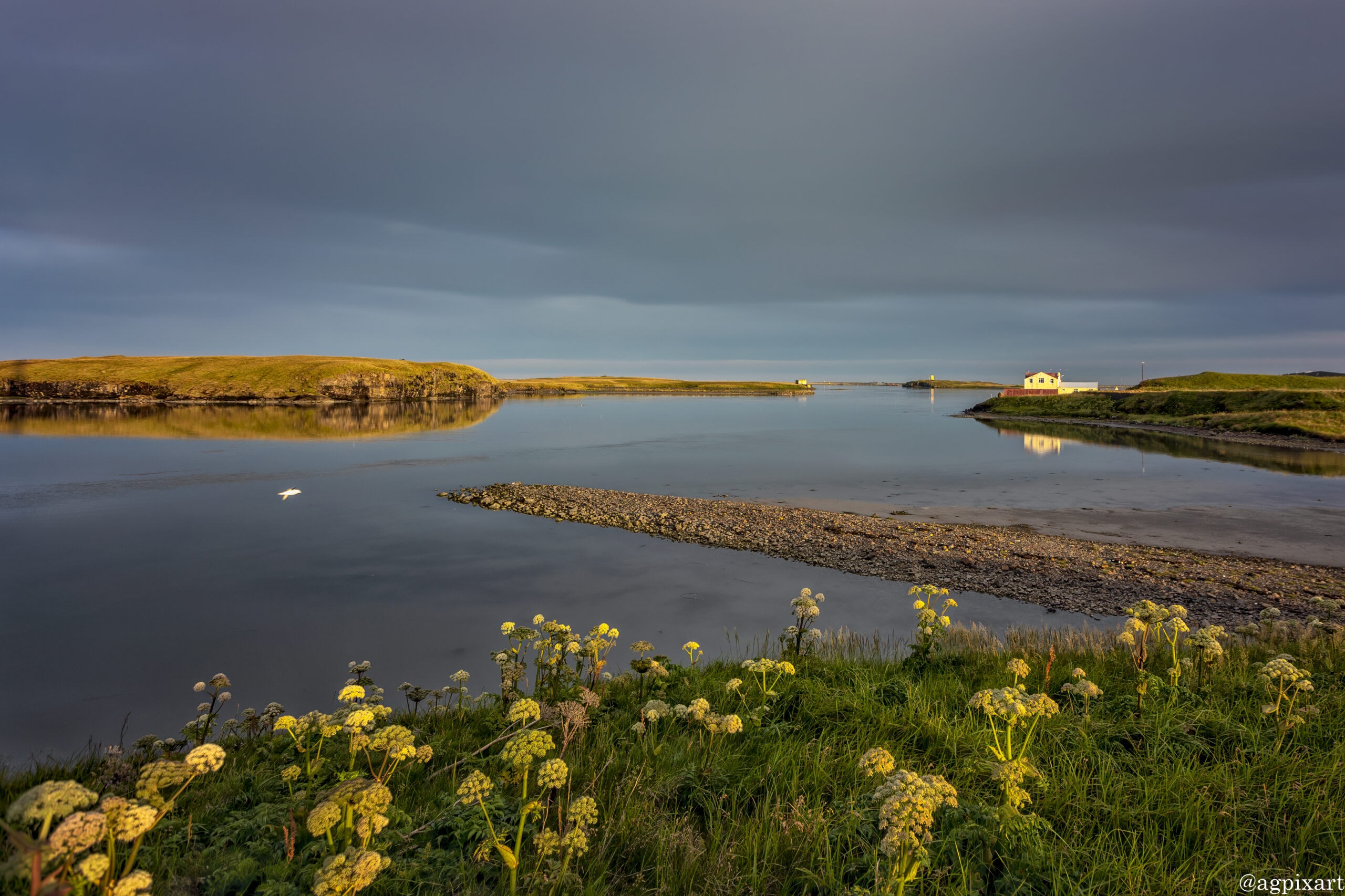
The largest town in Southeast Iceland is Höfn í Hornafirði, often referred to simply as Höfn. It’s a fishing hub with a harbor and seafood restaurants, serving as a base for exploring the surroundings.
The main attraction in this region include Vatnajökull Glacier, Jökulsárlón Glacier Lagoon and Diamond Beach.


The East and South East

Route 939, is a scenic mountain pass in East Iceland that connects the towns of Djúpivogur and Egilsstaðir, providing a dramatic shortcut through the rugged landscape of the Eastfjords.

Folaldafoss is a lesser-known but enchanting waterfall located in the Eastfjords of Iceland, along the Öxi Pass (Route 939). The waterfall is formed by the Berufjarðará river, which squeezes through a narrow gap in the cliffs, creating a picturesque cascade into a small pool below.

Brunnhorn is located near the town of Höfn, nicknamed “The Batman Mountain” due to its three peaks, which resemble the Batman logo when viewed from certain angles. “Brunnhorn” translates to “Well Horn,” reflecting its horn-like appearance.

A charming coastal village of Hofn is the largest settlement in Southeast Iceland with a bustling harbor, known for its lobster (langoustine) dishes. It is a great stopping point for visitors and a good base for exploring the surrounding areas. It offers beautiful views of the Vatnajokull Glacier and the Atlantic Ocean.

Svínafellsjökull is an outlet or “tongue” glacier, extending from the larger Vatnajökull ice cap. Known for its deep blue ice, crevasses, and seracs, which are vertical ice pinnacles formed by the glacier’s movement.

It is one of Europe’s largest national parks that encompasses a vast area in Southeast Iceland, covering approximately 14% of the country’s surface. Vatnajökull National Park is accessible via the Ring Road (Route 1) with several key entry points. The park includes archaeological and historical sites, showing traces of human settlement from Viking times to the present.

Often referred to as the Glacier Lagoon is one of Iceland’s most famous attractions, where icebergs calve off the glacier into a lagoon that then flows into the ocean. ökulsárlón was formed by the retreat of the Breiðamerkurjökull glacier, one of Vatnajökull’s outlet glaciers. The lagoon has been expanding since the 1930s due to ongoing glacier melting. The lagoon is famous for its large, floating icebergs that break off from the glacier. These icebergs vary in size and can be seen drifting towards the ocean.

Diamond Beach is located next to Jökulsárlón Glacier Lagoon gets its name from the ice chunks that wash up from Jökulsárlón onto the black sand shore. These icebergs, often transparent or blue, look like scattered diamonds against the dark sand, creating an ethereal landscape. Depending on the weather and time of day, the ice can exhibit a range of colors from clear to blue, with some pieces even showing layers of ash from past volcanic eruptions.

Hofskirkja is one of Iceland’s most iconic turf churches located near the village of Hof. It is one of the last turf churches built in Iceland, constructed in 1884. The term “turf church” refers to the building method where the walls and roof are covered with turf or grass, providing excellent insulation in Iceland’s harsh climate. The church’s structure is made of timber with stone walls and a roof covered in turf, blending seamlessly into the landscape. This construction technique was common in Iceland due to the scarcity of wood. Surrounding the church is a graveyard, with mounds that look like they are emerging from the grass, adding to the mystical atmosphere.

Svartifoss, known as the “Black Falls ” is renowned for its hexagonal basalt columns providing a unique natural architecture. Svartifoss is reachable from the Skaftafell Visitor Centre via a well-maintained hiking trail. The trail to Svartifoss is about 1.8 km one way (3.6 km round trip) with a moderate incline. It typically takes around 45 minutes to an hour to reach the falls, depending on your pace.

The Gigjukvisl Bridge Memorial, also known as the Skeiðará Bridge Monument. In November 1996, a massive glacial outburst flood (jökulhlaup) occurred due to the eruption beneath the Vatnajökull glacier, specifically from the Grímsvötn volcanic system. This flood led to the destruction of the Gigjukvisl Bridge, part of the Ring Road. The flood carried enormous ice floes, with some icebergs weighing up to 5,000 tons, which struck and demolished the bridge. The water flow rate reached an astonishing 50,000 cubic meters per second. What remains of the bridge are two severely twisted steel girders, left as a monument to the power of nature and the resilience of human efforts to rebuild in such environments.

Lómagnúpur is a subglacial mound, formed by volcanic activity under an ice cap during the Ice Age. It’s composed mainly of palagonite, with layers of lava and sediment, giving it a distinct layered appearance. Lómagnúpur is featured in Icelandic folklore, notably as the home of a giant named Jarngrimur, believed to protect the south coast of Iceland from invaders. The mountain appears in the 13th-century Icelandic saga, “Njáls saga,” where a chieftain named Flosi has a prophetic dream about the mountain.

Foss á Síðu or “Waterfall on the Side,” is a scenic waterfall located near the town of Kirkjubæjarklaustur. The waterfall is formed by the small river Fossá, which cascades over a cliff into a lush, green setting. It’s not particularly high or wide compared to some of Iceland’s more famous waterfalls, but its charm lies in its accessibility and the picturesque environment.

Stjórnarfoss, also known as “Government Falls,” is a picturesque waterfall located near the village of Kirkjubæjarklaustur. Stjórnarfoss drops about 15 meters (49 feet) over a rounded cliff, creating a broad, curtain-like waterfall that’s quite scenic. It has a distinctive dome shape due to the geological formation of the cliff it falls over. The waterfall is part of the river Stjórn, which flows through a beautiful landscape of cliffs and green slopes, adding to the waterfall’s charm.

Kirkjugólf, or “Church Floor,” is a unique geological feature near the village of Kirkjubæjarklaustur. Kirkjugólf is renowned for its hexagonal basalt column formation, which resembles the flooring of an old church, hence its name. These columns formed from cooled lava flows, similar to those seen at Svartifoss, but here they lie flat on the ground. The columns are part of a larger geological feature where the lava cooled in such a way that it created these regular, hexagonal shapes. Over time, erosion exposed this layer, creating the flat, tessellated “floor.”

Fjaðrárgljúfur is a stunning canyon in Southeast Iceland, known for its dramatic, serpentine shape and verdant beauty. The canyon was formed by the erosive action of the Fjaðrá river over millions of years, cutting through layers of rock to create a canyon around 100 meters deep and 2 kilometers long. Fjaðrárgljúfur is renowned for its winding, narrow path with high walls, providing a scenic and somewhat surreal landscape, especially when viewed from above.


Instructions for photo proofing and comments:

Left-click on the photo to access options for title information (i), leave comment, or mark the photo(s) as the favorite. The option to submit the selected as favorite photos is under “Submit proofs” button under photo gallery.


The East and South East Photos
(Click on Photo for More Info)

Other Regions of Iceland

Home » Destinations » Europe » Iceland » EastandSouthEast