
The North
North Iceland, or Norðurland in Icelandic, is a region known for its dramatic landscapes like waterfalls, lakes, lava formations, pseudocraters and rich birdlife making it a compelling destination for tourists seeking both adventure and a deep dive into Icelandic history and culture.
Explore The North
The North region is quite a distance from Reykjavik, but well-connected by the Ring Road (Route 1), the main road in the country that circles the island. The journey typically takes around five to six hours by car. Many attractions require detours on smaller, sometimes gravel roads.
North Iceland is home to several charming towns and villages with rich cultural heritage, and offers activities like whale-watching as well as exploring natural attractions and unique landscapes.
The North
Akureyri, the “Capital of the North”, is the largest settlement outside of the Greater Reykjavík Area. It is located by the coast of the Eyjafjordur fjord. The older part of Akureyri is particularly charming and worth a stroll, as it contains many historic buildings. The town is also home to many interesting museums, galleries, and the world’s northernmost botanical gardens.
The Old Turfhouse Laufás, located in Eyjafjörður in North Iceland, is a significant historical and architectural site offering insights into the traditional Icelandic way of life. The current structures, were mostly built between 1866 and 1870 by Reverend Björn Halldórsson, with parts dating back to 1840. Originally a vicarage, Laufás was home to priests and their families, often accommodating up to 20-30 people, including household staff and workers. Laufás is one of the best-preserved examples of Icelandic turf houses, which were common until the 20th century. These buildings are constructed with layers of turf and stone, providing excellent insulation against Iceland’s harsh climate. The house consists of several interconnected rooms, which include living areas, kitchens, storage, and even a bridal chamber, showcasing how space was utilized in these multi-functional homes. Adjacent to the turf house, there’s a white timber church from 1865, featuring a notable pulpit from 1698, adding to the historical value of the site.
Husavik is a charming coastal town nestled on the shores of Skjalfandi bay that is known as the whale watching capital of Iceland, with opportunities to see numerous whale species. Visitors can embark on boat tours from the town’s harbor to observe majestic whales, dolphins, and other marine life in their natural habitat. Another popular activity in town is geothermal bathing at the GeoSea Geothermal Sea Baths. The complex features a series of infinity pools filled with mineral-rich seawater and underground water. Here, guests can relax in the warm waters while soaking in the natural beauty of the North Icelandic coastline.
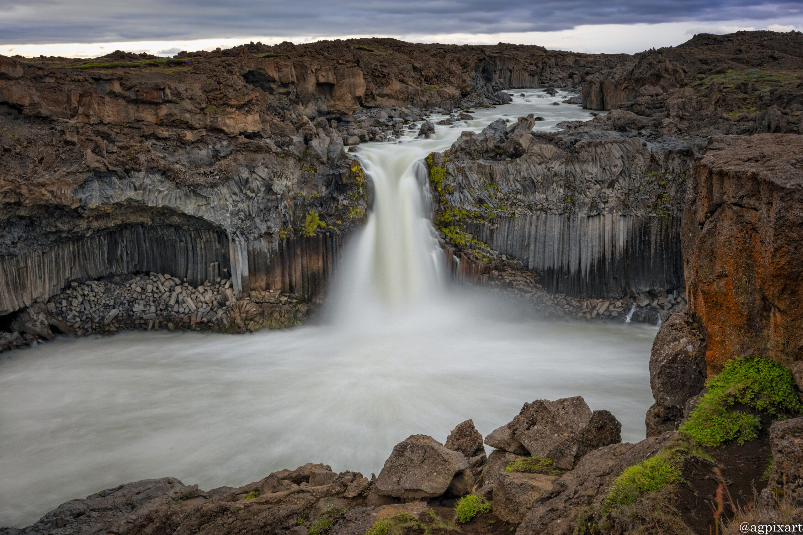
Aldeyjarfoss is renowned for its dramatic backdrop of black hexagonal basalt columns, which frame the waterfall, giving it a unique and almost otherworldly appearance. These columns are a result of cooled lava flows. The waterfall itself drops about 20 meters (66 feet) into a narrow canyon, creating a spectacular sight. The waterfall is relatively remote, requiring a drive from Akureyri or Mývatn. The turnoff from Route 1 (the Ring Road) is near the village of Húsavík or the town of Akureyri, following road 841 towards Sprengisandur, then taking a gravel road. It’s advisable to check road conditions, especially in winter, as the area can be snowy and icy, and a 4×4 vehicle might be necessary.
Waterfall of the Gods is situated in the Bárðardalur valley of North Iceland, near the Ring Road (Route 1), making it easily accessible to tourists traveling around the island. It’s roughly 37 kilometers east of Akureyri, the largest town in North Iceland. The waterfall’s name is derived from its horseshoe shape, which some compare to a traditional Norse pagan altar, contributing to its historical significance. The most famous story associated with Goðafoss relates to the conversion of Iceland to Christianity around the year 1000 AD. According to the Sagas, Þorgeir Ljósvetningagoði, the law speaker, decided that Iceland would switch from Norse paganism to Christianity. In a symbolic act, he threw his statues of the Norse gods into the waterfall, thus naming it “Goðafoss.”
The lake was formed by a large volcanic eruption around 2300 years ago, which led to the creation of lava fields that dammed the water into what is now Lake Mývatn. Famous for its clear waters, birdlife, and geothermal features like the pseudo-craters of Skútustaðir, lava fields, and hot springs. Pseudocraters are not true volcanoes but formed when hot lava flowed over wet ground or into the lake, causing explosions that built up the crater-like structures. The lake itself is remarkably shallow, averaging 8 feet (2.5 meters).
Fuglasafn Sigurgeirs is easily accessible from the Ring Road (Route 1), with signage leading to the museum. It’s a short drive from Reykjahlíð village on the northwest side of Lake Mývatn. The museum was named after Sigurgeir Stefánsson, a local man who was passionate about birds. He began collecting bird specimens as a young boy and had amassed a significant collection by the time of his tragic death in 1999 at the age of 37. It houses one of the largest private bird collections in Iceland, with over 300 specimens representing more than 180 species, including virtually all breeding birds in Iceland.
Mývatn Nature Baths, often referred to as the “Blue Lagoon of the North,” is a geothermal spa located in North Iceland, near Lake Mývatn. The main attraction is the large, milky-blue geothermal lagoon, where the water temperature averages around 38-40°C (100-104°F). The geothermal water is rich in minerals, particularly silica, which is believed to have beneficial effects on the skin.
The cave is a small gorge with a partially collapsed roof, revealing a hidden pool of geothermal water. This gorge was formed by tectonic movements in the area. The water in Grjótagjá is heated by underground geothermal activity, which makes the pool naturally warm. However, the water temperature has varied significantly over the years due to volcanic activity in the region. Historically, Grjótagjá was used as a bathing spot by locals. It became particularly famous through the Icelandic Sagas, where it’s mentioned as a romantic meeting place for lovers. The cave gained international recognition when it was featured in HBO’s series “Game of Thrones” as one of the locations where Jon Snow and Ygritte share an intimate moment.
Dimmuborgir, which translates to “Dark Castles” or “Dark Cities” in Icelandic, is a remarkable geological formation resulting from of a massive volcanic eruption around 2,300 years ago. Lava flowed over a large area of wet moss and peat, which then burned and formed hollows in the lava as it cooled, creating the unique cave and pillar structures seen today. The lava field features dramatic rock formations that resemble castles, towers, and cathedrals, some reaching up to 20 meters in height. This has led to the nickname “Dark Cities” due to the complex and imposing nature of the structures. Dimmuborgir is steeped in Icelandic folklore, believed by some to be the entrance to Hell or the abode of trolls and elves. One of the most famous tales involves the giant Grýla, who is said to live in the area. During the Christmas season, Dimmuborgir, particularly near Hallarflöt, hosts events where visitors can meet the Yule Lads, adding a festive and cultural element to the site.
Hverir, often referred to as Hverir geothermal area or “Hverir – Boiling Mud,” is one of Iceland’s most visually striking geothermal sites. The area is famous for its numerous mud pools, where mud boils and bubbles due to the geothermal heat beneath the surface. The mud’s colors range from gray to vibrant yellow and orange due to mineral deposits. Hverir is also known for its fumaroles, vents from which hot steam and volcanic gases escape, creating a misty, otherworldly atmosphere. The sound of escaping steam adds to the experience. Sulfur-rich fumaroles called solfataras give the area its distinctive, sometimes pungent, smell of sulfur or “rotten eggs.”
The power station is accessible via Route 863, which branches off from the Ring Road (Route 1). Signs direct visitors to Krafla, and there’s a parking area near the power plant for those interested in visiting. Krafla Power Station harnesses geothermal energy to generate electricity, contributing significantly to Iceland’s renewable energy portfolio. The plant has an installed capacity of around 60 MW of electricity and also produces hot water for district heating. Krafla sits atop one of Iceland’s most active geothermal fields. The area is characterized by fumaroles, hot springs, and the famous Víti crater, showcasing the direct link between the power station’s operations and Iceland’s volcanic activity.
Víti was formed during the Krafla Fires, a series of volcanic eruptions between 1975 and 1984. The name “Víti” translates to “Hell” or “Purgatory” in Icelandic, reflecting its fiery origin and appearance. The crater at Krafla contains a vivid, blue-green geothermal lake, which is heated by underground volcanic activity. The water temperature can be quite hot, often around 25-30°C (77-86°F) or even higher in some spots, but it’s not recommended for bathing due to its variable temperatures and the risk of burns from geothermal activity.
Ásbyrgi Canyon is located within Vatnajökull National Park and it is known for its horseshoe shape that extends 2.2 miles (3.5 kilometers) long and 0.7 miles (1.1 kilometers) wide and is often referred to as a “hoofprint”. According to Norse mythology, Asbyrgi is believed to been created by the hoofprint of god Odin’s eight-legged horse, Sleipnir, when it touched the ground.
Europe’s most powerful waterfall, located in Vatnajökull National Park, offering breathtaking views and hiking opportunities. Dettifoss is known for its sheer power, with water flow rates that can exceed 500 cubic meters per second during peak times. It’s about 100 meters wide and has a drop of around 44 meters. There are two main approaches. East Side – Via Road 864, which is unpaved but offers closer access to Dettifoss. This road can be rough and requires caution, especially in bad weather or if you’re not driving a vehicle suitable for gravel roads. West Side – Road 862 provides access from the west, which is a smoother, paved road but involves a slightly longer walk to the falls. It’s generally more accessible for all vehicle types.
Movie buffs may recognize its wide cascade being featured in the opening scene of the 2012 movie Prometheus.
Egilsstaðir is strategically located on the Ring Road (Route 1), making it a key stop for travelers circling Iceland. Situated on the banks of the Lagarfljót River, surrounded by a landscape of mountains, forests, and fjords.
Instructions for photo proofing and comments:
Left-click on the photo to access options for title information (i), leave comment, or mark the photo(s) as the favorite. The option to submit the selected as favorite photos is under “Submit proofs” button under photo gallery.